AA: Big Road Atlas France 2020
£0.10

AA: Big Road Atlas France 2020

AA: Big Road Atlas France 2020
Item No.
WKS_9780749581725
£0.10
Was £0.50
RRP
£9.99
Save £9.89
(99% Off RRP)
Out of stock
FREE Standard Delivery (£3.99 on orders under £30)
Delivered within 3 working days
Delivered within 3 working days
Not available for Standard Delivery
Not available for Next Day Delivery
Available for Click & Collect
Select Store Select Store
Select Store Select Store
This bundle includes the following products:
AA: Big Road Atlas France 2020
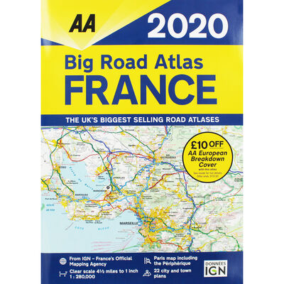
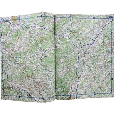
This A3 format road atlas of France provides clear scale mapping, at 4.5 miles to 1 inch.
Fully revised and updated for 2020, it has been designed for the British motorist in France and includes 21 city / town plans. There is also a channel hopping guide including channel tunnel terminal plans and ferry information.
Coverage includes road mapping for Corsica and a central city and regional plan of Paris, plus the atlas legend is in English, French, Spanish, Italian, German and Dutch.
There are also over 18,500 tourist sites shown on the mapping and French place names used to match local road signs.
Product Information:
• ISBN: 9780749581725
• Author: AA
• Publisher: AA
• Format: Paperback
• Pages: 108
• Dimensions: 39 x 28 x 1cm
EXCLUDED FROM PROMOTIONS
FREE Standard Delivery (£3.99 on orders under £30)
Delivered within 3 working days
Delivered within 3 working days
Not available for Standard Delivery
Not available for Next Day Delivery
Not available for Click & Collect
FREE Click & Collect (£2.99 on orders under £10)
Delivered within 3 working days - Check store stock
We're sorry, we couldn't find results for your search.
Not available for Parcelshop
FREE Parcelshop Collection (£3.99 on orders under £30)
Delivered within 3 working days
AA: Big Road Atlas France 2020
This A3 format road atlas of France provides clear scale mapping, at 4.5 miles to 1 inch.
Fully revised and updated for 2020, it has been designed for the British motorist in France and includes 21 city / town plans. There is also a channel hopping guide including channel tunnel terminal plans and ferry information.
Coverage includes road mapping for Corsica and a central city and regional plan of Paris, plus the atlas legend is in English, French, Spanish, Italian, German and Dutch.
There are also over 18,500 tourist sites shown on the mapping and French place names used to match local road signs.
Product Information:
• ISBN: 9780749581725
• Author: AA
• Publisher: AA
• Format: Paperback
• Pages: 108
• Dimensions: 39 x 28 x 1cm
Fully revised and updated for 2020, it has been designed for the British motorist in France and includes 21 city / town plans. There is also a channel hopping guide including channel tunnel terminal plans and ferry information.
Coverage includes road mapping for Corsica and a central city and regional plan of Paris, plus the atlas legend is in English, French, Spanish, Italian, German and Dutch.
There are also over 18,500 tourist sites shown on the mapping and French place names used to match local road signs.
Product Information:
• ISBN: 9780749581725
• Author: AA
• Publisher: AA
• Format: Paperback
• Pages: 108
• Dimensions: 39 x 28 x 1cm
EXCLUDED FROM PROMOTIONS
FREE Standard Delivery (£3.99 on orders under £30)
Delivered within 3 working days
Delivered within 3 working days
Not available for Standard Delivery
Not available for Next Day Delivery
Not available for Click & Collect
FREE Click & Collect (£2.99 on orders under £10)
Delivered within 3 working days - Check store stock
We're sorry, we couldn't find results for your search.
Not available for Parcelshop
FREE Parcelshop Collection (£3.99 on orders under £30)
Delivered within 3 working days